Satellite Imagery
Notebook Satellite images are returned by Python AWIPS as grids, and can be rendered with Cartopy pcolormesh the same as gridded forecast models in other python-awips examples.
Available Sources, Creating Entities, Sectors, and Products
from awips.dataaccess import DataAccessLayer
import cartopy.crs as ccrs
import cartopy.feature as cfeat
import matplotlib.pyplot as plt
from cartopy.mpl.gridliner import LONGITUDE_FORMATTER, LATITUDE_FORMATTER
import numpy as np
import datetime

# Create an EDEX data request
DataAccessLayer.changeEDEXHost("edex-cloud.unidata.ucar.edu")
request = DataAccessLayer.newDataRequest()
request.setDatatype("satellite")

# get optional identifiers for satellite datatype
identifiers = set(DataAccessLayer.getOptionalIdentifiers(request))

print("Available Identifiers:")
for id in identifiers:
    if id.lower() == 'datauri':
        continue
    print(" - " + id)
Available Identifiers:
 - physicalElement
 - creatingEntity
 - source
 - sectorID
# Show available sources
identifier = "source"
sources = DataAccessLayer.getIdentifierValues(request, identifier)
print(identifier + ":")
print(list(sources))
source:
['NESDIS', 'WCDAS', 'NSOF', 'UCAR', 'McIDAS']
# Show available creatingEntities
identifier = "creatingEntity"
creatingEntities = DataAccessLayer.getIdentifierValues(request, identifier)
print(identifier + ":")
print(list(creatingEntities))
creatingEntity:
['GOES-16', 'Composite', 'GOES-15(P)', 'POES-NPOESS', 'UNIWISC', 'GOES-11(L)', 'Miscellaneous', 'GOES-17', 'NEXRCOMP']
# Show available sectorIDs
identifier = "sectorID"
sectorIDs = DataAccessLayer.getIdentifierValues(request, identifier)
print(identifier + ":")
print(list(sectorIDs))
sectorID:
['EMESO-2', 'Northern Hemisphere Composite', 'EFD', 'TCONUS', 'Arctic', 'TFD', 'PRREGI', 'GOES-Sounder', 'EMESO-1', 'NEXRCOMP', 'ECONUS', 'GOES-West', 'Antarctic', 'GOES-East', 'Supernational', 'West CONUS', 'NH Composite - Meteosat-GOES E-GOES W-GMS']
# Contrust a full satellite product tree
for entity in creatingEntities:
    print(entity)
    request = DataAccessLayer.newDataRequest("satellite")
    request.addIdentifier("creatingEntity", entity)
    availableSectors = DataAccessLayer.getAvailableLocationNames(request)
    availableSectors.sort()
    for sector in availableSectors:
        print(" - " + sector)
        request.setLocationNames(sector)
        availableProducts = DataAccessLayer.getAvailableParameters(request)
        availableProducts.sort()
        for product in availableProducts:
            print("    - " + product)
GOES-16
 - ECONUS
    - ACTP
    - ADP
    - AOD
    - CAPE
    - CH-01-0.47um
    - CH-02-0.64um
    - CH-03-0.87um
    - CH-04-1.38um
    - CH-05-1.61um
    - CH-06-2.25um
    - CH-07-3.90um
    - CH-08-6.19um
    - CH-09-6.95um
    - CH-10-7.34um
    - CH-11-8.50um
    - CH-12-9.61um
    - CH-13-10.35um
    - CH-14-11.20um
    - CH-15-12.30um
    - CH-16-13.30um
    - CSM
    - CTH
    - FDC Area
    - FDC Power
    - FDC Temp
    - KI
    - LI
    - LST
    - SI
    - TPW
    - TT
    - VMP-0.00hPa
    - VMP-0.02hPa
    - VMP-0.04hPa
    - VMP-0.08hPa
    - VMP-0.14hPa
    - VMP-0.22hPa
    - VMP-0.35hPa
    - VMP-0.51hPa
    - VMP-0.71hPa
    - VMP-0.98hPa
    - VMP-1.30hPa
    - VMP-1.69hPa
    - VMP-1013.95hPa
    - VMP-103.02hPa
    - VMP-1042.23hPa
    - VMP-1070.92hPa
    - VMP-11.00hPa
    - VMP-110.24hPa
    - VMP-1100.00hPa
    - VMP-117.78hPa
    - VMP-12.65hPa
    - VMP-125.65hPa
    - VMP-133.85hPa
    - VMP-14.46hPa
    - VMP-142.38hPa
    - VMP-151.27hPa
    - VMP-16.43hPa
    - VMP-160.50hPa
    - VMP-170.08hPa
    - VMP-18.58hPa
    - VMP-180.02hPa
    - VMP-190.32hPa
    - VMP-2.15hPa
    - VMP-2.70hPa
    - VMP-20.92hPa
    - VMP-200.99hPa
    - VMP-212.03hPa
    - VMP-223.44hPa
    - VMP-23.45hPa
    - VMP-235.23hPa
    - VMP-247.41hPa
    - VMP-259.97hPa
    - VMP-26.18hPa
    - VMP-272.92hPa
    - VMP-286.26hPa
    - VMP-29.12hPa
    - VMP-3.34hPa
    - VMP-300.00hPa
    - VMP-314.14hPa
    - VMP-32.27hPa
    - VMP-328.68hPa
    - VMP-343.62hPa
    - VMP-35.65hPa
    - VMP-358.97hPa
    - VMP-374.72hPa
    - VMP-39.26hPa
    - VMP-390.89hPa
    - VMP-4.08hPa
    - VMP-4.92hPa
    - VMP-407.47hPa
    - VMP-424.47hPa
    - VMP-43.10hPa
    - VMP-441.88hPa
    - VMP-459.71hPa
    - VMP-47.19hPa
    - VMP-477.96hPa
    - VMP-496.63hPa
    - VMP-5.88hPa
    - VMP-51.53hPa
    - VMP-515.72hPa
    - VMP-535.23hPa
    - VMP-555.17hPa
    - VMP-56.13hPa
    - VMP-575.52hPa
    - VMP-596.31hPa
    - VMP-6.96hPa
    - VMP-60.99hPa
    - VMP-617.51hPa
    - VMP-639.14hPa
    - VMP-66.13hPa
    - VMP-661.19hPa
    - VMP-683.67hPa
    - VMP-706.57hPa
    - VMP-71.54hPa
    - VMP-729.89hPa
    - VMP-753.63hPa
    - VMP-77.24hPa
    - VMP-777.79hPa
    - VMP-8.17hPa
    - VMP-802.37hPa
    - VMP-827.37hPa
    - VMP-83.23hPa
    - VMP-852.79hPa
    - VMP-878.62hPa
    - VMP-89.52hPa
    - VMP-9.51hPa
    - VMP-904.87hPa
    - VMP-931.52hPa
    - VMP-958.59hPa
    - VMP-96.11hPa
    - VMP-986.07hPa
    - VTP-0.00hPa
    - VTP-0.02hPa
    - VTP-0.04hPa
    - VTP-0.08hPa
    - VTP-0.14hPa
    - VTP-0.22hPa
    - VTP-0.35hPa
    - VTP-0.51hPa
    - VTP-0.71hPa
    - VTP-0.98hPa
    - VTP-1.30hPa
    - VTP-1.69hPa
    - VTP-1013.95hPa
    - VTP-103.02hPa
    - VTP-1042.23hPa
    - VTP-1070.92hPa
    - VTP-11.00hPa
    - VTP-110.24hPa
    - VTP-1100.00hPa
    - VTP-117.78hPa
    - VTP-12.65hPa
    - VTP-125.65hPa
    - VTP-133.85hPa
    - VTP-14.46hPa
    - VTP-142.38hPa
    - VTP-151.27hPa
    - VTP-16.43hPa
    - VTP-160.50hPa
    - VTP-170.08hPa
    - VTP-18.58hPa
    - VTP-180.02hPa
    - VTP-190.32hPa
    - VTP-2.15hPa
    - VTP-2.70hPa
    - VTP-20.92hPa
    - VTP-200.99hPa
    - VTP-212.03hPa
    - VTP-223.44hPa
    - VTP-23.45hPa
    - VTP-235.23hPa
    - VTP-247.41hPa
    - VTP-259.97hPa
    - VTP-26.18hPa
    - VTP-272.92hPa
    - VTP-286.26hPa
    - VTP-29.12hPa
    - VTP-3.34hPa
    - VTP-300.00hPa
    - VTP-314.14hPa
    - VTP-32.27hPa
    - VTP-328.68hPa
    - VTP-343.62hPa
    - VTP-35.65hPa
    - VTP-358.97hPa
    - VTP-374.72hPa
    - VTP-39.26hPa
    - VTP-390.89hPa
    - VTP-4.08hPa
    - VTP-4.92hPa
    - VTP-407.47hPa
    - VTP-424.47hPa
    - VTP-43.10hPa
    - VTP-441.88hPa
    - VTP-459.71hPa
    - VTP-47.19hPa
    - VTP-477.96hPa
    - VTP-496.63hPa
    - VTP-5.88hPa
    - VTP-51.53hPa
    - VTP-515.72hPa
    - VTP-535.23hPa
    - VTP-555.17hPa
    - VTP-56.13hPa
    - VTP-575.52hPa
    - VTP-596.31hPa
    - VTP-6.96hPa
    - VTP-60.99hPa
    - VTP-617.51hPa
    - VTP-639.14hPa
    - VTP-66.13hPa
    - VTP-661.19hPa
    - VTP-683.67hPa
    - VTP-706.57hPa
    - VTP-71.54hPa
    - VTP-729.89hPa
    - VTP-753.63hPa
    - VTP-77.24hPa
    - VTP-777.79hPa
    - VTP-8.17hPa
    - VTP-802.37hPa
    - VTP-827.37hPa
    - VTP-83.23hPa
    - VTP-852.79hPa
    - VTP-878.62hPa
    - VTP-89.52hPa
    - VTP-9.51hPa
    - VTP-904.87hPa
    - VTP-931.52hPa
    - VTP-958.59hPa
    - VTP-96.11hPa
    - VTP-986.07hPa
 - EFD
    - ACTP
    - ADP
    - AOD
    - CAPE
    - CH-01-0.47um
    - CH-02-0.64um
    - CH-03-0.87um
    - CH-04-1.38um
    - CH-05-1.61um
    - CH-06-2.25um
    - CH-07-3.90um
    - CH-08-6.19um
    - CH-09-6.95um
    - CH-10-7.34um
    - CH-11-8.50um
    - CH-12-9.61um
    - CH-13-10.35um
    - CH-14-11.20um
    - CH-15-12.30um
    - CH-16-13.30um
    - CSM
    - CTH
    - CTT
    - FDC Area
    - FDC Power
    - FDC Temp
    - KI
    - LI
    - LST
    - RRQPE
    - SI
    - SST
    - TPW
    - TT
    - VAH
    - VAML
 - EMESO-1
    - ACTP
    - ADP
    - CAPE
    - CH-01-0.47um
    - CH-02-0.64um
    - CH-03-0.87um
    - CH-04-1.38um
    - CH-05-1.61um
    - CH-06-2.25um
    - CH-07-3.90um
    - CH-08-6.19um
    - CH-09-6.95um
    - CH-10-7.34um
    - CH-11-8.50um
    - CH-12-9.61um
    - CH-13-10.35um
    - CH-14-11.20um
    - CH-15-12.30um
    - CH-16-13.30um
    - CSM
    - CTH
    - CTT
    - KI
    - LI
    - LST
    - SI
    - TPW
    - TT
 - EMESO-2
    - ACTP
    - ADP
    - CAPE
    - CH-01-0.47um
    - CH-02-0.64um
    - CH-03-0.87um
    - CH-04-1.38um
    - CH-05-1.61um
    - CH-06-2.25um
    - CH-07-3.90um
    - CH-08-6.19um
    - CH-09-6.95um
    - CH-10-7.34um
    - CH-11-8.50um
    - CH-12-9.61um
    - CH-13-10.35um
    - CH-14-11.20um
    - CH-15-12.30um
    - CH-16-13.30um
    - CSM
    - CTH
    - CTT
    - KI
    - LI
    - LST
    - SI
    - TPW
    - TT
 - PRREGI
    - CH-01-0.47um
    - CH-02-0.64um
    - CH-03-0.87um
    - CH-04-1.38um
    - CH-05-1.61um
    - CH-06-2.25um
    - CH-07-3.90um
    - CH-08-6.19um
    - CH-09-6.95um
    - CH-10-7.34um
    - CH-11-8.50um
    - CH-12-9.61um
    - CH-13-10.35um
    - CH-14-11.20um
    - CH-15-12.30um
    - CH-16-13.30um
Composite
 - NH Composite - Meteosat-GOES E-GOES W-GMS
    - Imager 11 micron IR
    - Imager 6.7-6.5 micron IR (WV)
    - Imager Visible
 - Supernational
    - Gridded Cloud Amount
    - Gridded Cloud Top Pressure or Height
    - Sounder Based Derived Lifted Index (LI)
    - Sounder Based Derived Precipitable Water (PW)
    - Sounder Based Derived Surface Skin Temp (SFC Skin)
GOES-15(P)
 - Northern Hemisphere Composite
    - Imager 11 micron IR
    - Imager 6.7-6.5 micron IR (WV)
    - Imager Visible
 - Supernational
    - Imager 11 micron IR
    - Imager 6.7-6.5 micron IR (WV)
    - Imager Visible
 - West CONUS
    - Imager 11 micron IR
    - Imager 13 micron IR
    - Imager 3.9 micron IR
    - Imager 6.7-6.5 micron IR (WV)
    - Imager Visible
    - Sounder 11.03 micron imagery
    - Sounder 14.06 micron imagery
    - Sounder 3.98 micron imagery
    - Sounder 4.45 micron imagery
    - Sounder 6.51 micron imagery
    - Sounder 7.02 micron imagery
    - Sounder 7.43 micron imagery
    - Sounder Visible imagery
POES-NPOESS
 - Supernational
    - Rain fall rate
UNIWISC
 - Antarctic
    - Imager 11 micron IR
    - Imager 12 micron IR
    - Imager 3.5-4.0 micron IR (Fog)
    - Imager 6.7-6.5 micron IR (WV)
    - Imager Visible
 - Arctic
    - Imager 11 micron IR
    - Imager 12 micron IR
    - Imager 3.5-4.0 micron IR (Fog)
    - Imager 6.7-6.5 micron IR (WV)
    - Imager Visible
 - GOES-East
    - Imager 11 micron IR
    - Imager 13 micron IR
    - Imager 3.5-4.0 micron IR (Fog)
    - Imager 6.7-6.5 micron IR (WV)
    - Imager Visible
 - GOES-Sounder
    - CAPE
    - Sounder Based Derived Lifted Index (LI)
    - Sounder Based Derived Precipitable Water (PW)
    - Sounder Based Total Column Ozone
 - GOES-West
    - Imager 11 micron IR
    - Imager 13 micron IR
    - Imager 3.5-4.0 micron IR (Fog)
    - Imager 6.7-6.5 micron IR (WV)
    - Imager Visible
GOES-11(L)
 - West CONUS
    - Low cloud base imagery
Miscellaneous
 - Supernational
    - Percent of Normal TPW
    - Sounder Based Derived Precipitable Water (PW)
GOES-17
 - TCONUS
    - CH-01-0.47um
    - CH-02-0.64um
    - CH-03-0.87um
    - CH-04-1.38um
    - CH-05-1.61um
    - CH-06-2.25um
    - CH-07-3.90um
    - CH-08-6.19um
    - CH-09-6.95um
    - CH-10-7.34um
    - CH-11-8.50um
    - CH-12-9.61um
    - CH-13-10.35um
    - CH-14-11.20um
    - CH-15-12.30um
    - CH-16-13.30um
 - TFD
    - CH-01-0.47um
    - CH-02-0.64um
    - CH-03-0.87um
    - CH-04-1.38um
    - CH-05-1.61um
    - CH-06-2.25um
    - CH-07-3.90um
    - CH-08-6.19um
    - CH-09-6.95um
    - CH-10-7.34um
    - CH-11-8.50um
    - CH-12-9.61um
    - CH-13-10.35um
    - CH-14-11.20um
    - CH-15-12.30um
    - CH-16-13.30um
NEXRCOMP
 - NEXRCOMP
    - DHR
    - DVL
    - EET
    - HHC
    - N0R
    - N1P
    - NTP
GOES 16 Mesoscale Sectors
Define our imports, and define our map properties first.
%matplotlib inline
def make_map(bbox, projection=ccrs.PlateCarree()):
fig, ax = plt.subplots(figsize=(10,12),
subplot_kw=dict(projection=projection))
if bbox[0] is not np.nan:
ax.set_extent(bbox)
ax.coastlines(resolution='50m')
gl = ax.gridlines(draw_labels=True)
gl.top_labels = gl.right_labels = False
gl.xformatter = LONGITUDE_FORMATTER
gl.yformatter = LATITUDE_FORMATTER
return fig, ax
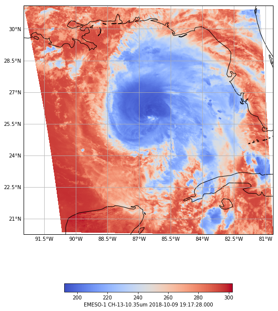
sectors = ["EMESO-1","EMESO-2"]
fig = plt.figure(figsize=(16,7*len(sectors)))
for i, sector in enumerate(sectors):
request = DataAccessLayer.newDataRequest()
request.setDatatype("satellite")
request.setLocationNames(sector)
request.setParameters("CH-13-10.35um")
utc = datetime.datetime.utcnow()
times = DataAccessLayer.getAvailableTimes(request)
hourdiff = utc - datetime.datetime.strptime(str(times[-1]),'%Y-%m-%d %H:%M:%S')
hours,days = hourdiff.seconds/3600,hourdiff.days
minute = str((hourdiff.seconds - (3600 * hours)) / 60)
offsetStr = ''
if hours > 0:
offsetStr += str(hours) + "hr "
offsetStr += str(minute) + "m ago"
if days > 1:
offsetStr = str(days) + " days ago"
response = DataAccessLayer.getGridData(request, [times[-1]])
grid = response[0]
data = grid.getRawData()
lons,lats = grid.getLatLonCoords()
bbox = [lons.min(), lons.max(), lats.min(), lats.max()]
print("Latest image available: "+str(times[-1]) + " ("+offsetStr+")")
print("Image grid size: " + str(data.shape))
print("Image grid extent: " + str(list(bbox)))
fig, ax = make_map(bbox=bbox)
states = cfeat.NaturalEarthFeature(category='cultural',
name='admin_1_states_provinces_lines',
scale='50m', facecolor='none')
ax.add_feature(states, linestyle=':')
cs = ax.pcolormesh(lons, lats, data, cmap='coolwarm')
cbar = fig.colorbar(cs, shrink=0.6, orientation='horizontal')
cbar.set_label(sector + " " + grid.getParameter() + " " \
+ str(grid.getDataTime().getRefTime()))
Latest image available: 2018-10-09 19:17:28 (0.021388888888888888hr 0.0m ago)
Image grid size: (500, 500)
Image grid extent: [-92.47462, -80.657455, 20.24799, 31.116167]
Latest image available: 2018-10-09 14:30:58 (4.797777777777778hr 0.0m ago)
Image grid size: (500, 500)
Image grid extent: [-104.61595, -87.45227, 29.422266, 42.70851]
<Figure size 1152x1008 with 0 Axes>