TCMWind Tool

March 9, 2012


The TCMWind tool was designed to read and decode the TCM text bulletin and create a sequence of wind grids based on the location and wind radii information. Forecasters can choose between the current forecast, NAM, or the GFS as background wind fields. The tool generates wind grids based on the local wind time constraints. For example, if a site configures the wind weather element such that there is a grid every hour, the tool will produce a wind grid every hour for the time span of the the TCM bulletin (usually 5 days).

Running the Tool

To run the TCMWind tool, select from the GFE main menu,

Populate->TCMWindTool.


As soon as the tool starts, it displays a dialog that looks like Figure 1 below. Using this dialog you can indicate the TCM bulletin that should be decoded, the background wind field, the eye diameter, the 34-knot radius at 3, 4, and 5 days, and whether you want the tool to make wind grids over the selected time range only. Each of the options are described in more detail below.

Product to decode

Each new tropical cyclone is assigned a slightly different product PIL. It is very important that you select the correct product name or the wrong TCM will be decoded and plotted. Use one of the first two columns of product PILs to select the appropriate product. One and only one selection is allowed. Any more or less than one will result in an error message in the form of a GFE yellow banner.


TCMWind tool user interface


Figure 1 - Snapshot of the TCMWindTool interface


Background Model


This is where you select the background for your grid. The tool will do its best to match the time of the model (or Fcst) grid with the time of the cyclone. The background grid is blended with the cyclone wind field so that you have winds defined over your entire domain.

Eye Diameter


TPC will generally report an observed eye diameter in the TCM bulletin. This value is used to calculate the radius of maximum wind (RMW) using this equation:

RMW = (EyeDiameter / 2.0) + 8.0

The value for this radius of maximum wind is used throughout the 5-day forecast period. If you wish to override this TPC value, move the slider bar to the right. Any value greater than zero will be used by the tool. If you do not adjust this slider, the value used will be the same as found in the TCM bulletin.

34 knot radius at 3 days (4 days) (5 days)

Beyond 72 hours, the TCM bulletin defines only a center location and maximum sustained wind at 24 hour intervals. To better define the spatial extent of the cyclone for the 3-5 day period, three sliders allow the forecasters to set the radius of the 34 knot wind threshold at 24 hour intervals. This is effectively the same as if the TCM bulletin defined 34 knot radii at these distances. To adjust the radii, simply move the slider to the desired value for each of the sliders.

Decrease Wind over Land by (%)

Adjusting this slider will reduce the wind magnitude over areas where the elevation is greater than zero (above sea level). Note that the scale range is from -20% to +50%. Negative values will increase the wind magnitude by that amount over areas above sea level.


Make Grid over Selected Time Only

Selecting “Yes” for this option will produce grids only over a time range that you select in the grid manager. Selecting “No” will cause the tool to create grids for the entire forecast period of the TCM bulletin. De-selecting the grid manager time range will have the same effect as selecting “No”. If you have a time range selected and select “Yes” to “Make Grid Over Selected Time Only”, but your selected time does not intersect the valid time of the TCM bulletin, a yellow banner will display informing you that you selected a time outside the time period defined in the bulletin.

MakeWind Swath for TCWindThreat?

This option is for use only by those offices that are part of Tropical Impact Graphics experiment. This option, using the detailed wind radii info provided calculates a swath of maximum wind for each grid point that incorporates the specified land friction. This creates a TCMMaxWindComposite object that gets stored in the server. When the office runs the TCWindThreat tool as part of the tropical impact grids/graphics, that object is available as one of two options for use as the deterministic WindMax source. In the context of the TCWindThreat tool, the WindMax source created by the TCMWindTools would be named TCM. The downside to running TCMWindTool with this option is that it will take 5 to 6 extra minutes to run.

The Algorithm

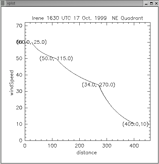
The algorithm used to calculate the wind field is roughly a Rankine vortex. Wind values at specified radii are defined in the TCM bulletin. Wind values between these radii are interpolated using an exponential curve. An example of this curve using forecast data from the northeast quadrant of Hurricane Irene (17 Oct 1999) is shown in Figure 2 below.


Rankine example


Figure 2 – Example of Rankine vortex algorithm that interpolates wind speed as a function of distance fro the center.


This process is repeated for each quadrant, based on the specified radii in the TCM bulletin. This technique is used to calculate the winds from the RMW outward. A linear curve is used to calculate wind values from the RMW toward the center.

Wind Speed Caps

Based on guidance from the TPC and the wind team, limitations on the magnitude of the wind are applied based on the forecast lead-time. These wind caps are documented in the table below.

Wind Caps for TCMWind Tool

Forecast period Maximum Allowed Wind Value
0 – 24 hours Maximum Sustained Wind
25-72 hours 100 knots
73-120 hours 64 knots


Table 1 – List of wind speed caps as a function of lead time.